• Help Support Hardline Crawlers :

reiter TRAILS (I am a clownpuncher) GPS cords???

JOOP

I WON a COOKIE
Joined
Mar 27, 2006
Messages
4,723
Reaction score
0
Location
Kitsap
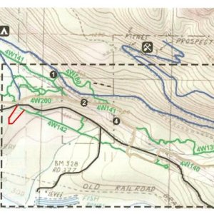
Does anyone have the GPS or Long/Lat to the pit? I know how to get there I'm working on a project and need the cordinates. :cool:


Oh and if you have the cordinates to the staging are for Evans creek and walker valley that woudl be supendus.:redneck:
Oh hell while I'm at it. The cordinates for these traisl too.

Elbe
Naches (probably the camp ground would do. I dont think there is really a staging area there)
rim rock
liberty


and any others if you guys can think of. :redneck:
 
Last edited:
PM Stokes or Hip. I'm not sure if Stokes is on here, but for sure SNORT.
Also, we like to refer to the area as Reiter Trails, not "Pit"

JOOP said:
Does anyone have the GPS or Long/Lat to the pit? I know how to get there I'm working on a project and need the cordinates. :cool:


Oh and if you have the cordinates to the staging are for Evans creek and walker valley that woudl be supendus.:redneck:
Oh hell while I'm at it. The cordinates for these traisl too.

Elbe
Naches (probably the camp ground would do. I dont think there is really a staging area there)
rim rock
liberty


and any others if you guys can think of. :redneck:
 
Hey, what are you doing with the lat long coordinates? What kind of project are you working on? you going to map out the whole area? I may be able to help. I have some ground cover data and ArcMap software i cant use to display your lat long points.
 
zig80toy said:
Hey, what are you doing with the lat long coordinates? What kind of project are you working on? you going to map out the whole area? I may be able to help. I have some ground cover data and ArcMap software i cant use to display your lat long points.
Zig,
Can you please let Hip know about your offer of help? I know they could use it.
Thanks
 
no we do not have one trail mapped...:mad:

i need someone who can actually do this to step up and voluntere but im tired of people promising stuff and never delivering. i have spent many days running trails so people can get the plots and i have absolutely nothing to show for all my efforts.

i have taken people out at least 4 times with GPSs and zero results.:mad:

i really really wanted this to be done a year ago and here we are a year later have nothing.:sad:

so please if you have the skills and equipment and are WILLING to help and not flake out on me i REALLY REALLY need it.
 
I dont have the skills. So I wont promise you anything. My GPS has mapping but I have no Idea how to download it. Plus I dont think it can. It's a Garmin GPSIII. I'm just trying to make a new WA trail database.
 
I have the skills but not the equipment. I work for the Utility mapping department for a local city. We have very nice GPS equipment but there is no way in hell i can take any of it home. But if someone has some GPS data they would be willing to give me, i can take it to work and see what i can do.
The tricky part: getting the files off the GPS equipment and turning them into a .shp file or something else i can use. Joop, thats where you come in. Try to figure out how to get the GPS files onto your computer and convert the data into something i can use. Im worried that the Garmin III might have its own file system and therefore other programs will not be able to read the data. Sorry i dont know anything about the Garmin system. We use Trimble GPS stuff here at work.
 
Here is what i was thinking. Need a GPS unit in a rig to take a point about every 10 feet or so down each trail.
Hard part: getting that data into ArcMap so i can play around with it.
After that everything will be easy. basically i can connect the dots to form lines (trails). Then decide which ground model to drape the lines over and "boom" we got a trail map. also, i can change the colors of different lines to represent "harder", all the way to "easier", trails.

Sorry to beat a dead horse here but: getting the data out of the GPS units and into useable form is the hang up.
 
zig80toy said:
Here is what i was thinking. Need a GPS unit in a rig to take a point about every 10 feet or so down each trail.
Hard part: getting that data into ArcMap so i can play around with it.
After that everything will be easy. basically i can connect the dots to form lines (trails). Then decide which ground model to drape the lines over and "boom" we got a trail map. also, i can change the colors of different lines to represent "harder", all the way to "easier", trails.

Sorry to beat a dead horse here but: getting the data out of the GPS units and into useable form is the hang up.

on the RTW forum under the mapping section there are some data download instructions written by Jason who was helping with this before he got so busy.

i cant get there (rtw forum) from work so i cant retrieve them till after work to post here. it explains how to save the data and what format to save it in. check it out and see if it will be compatable with your work stuff cause if it is i would REALLY like and appreciate the help. i posted it so you should be able to find it with the search engine.
 
Anyone wanna write a trail description of Reiter for me??? :cool:

Like directions, trail description, level of difficulty. etc..
 
JOOP said:
Anyone wanna write a trail description of Reiter for me??? :cool:

Like directions, trail description, level of difficulty. etc..


Directions: out on Rt 2

Trail description: Anything from tight and muddy to open and rocky.

Level of difficulty: Harder than Tahuya. :flipoff:
 
KarlVP said:
Directions: out on Rt 2

Trail description: Anything from tight and muddy to open and rocky. Just look for crash!!!

Level of difficulty: Harder than Tahuya. :flipoff:


Umm Looking for a better description than that. This trail system will have it's own page. each ORV park will have it's own page when I'm done with this . :cool:


Oh BTW wasn't it Tahuya that mangled your Bushwacker's?? :haha:
 
JOOP said:
Umm Looking for a better description than that. This trail system will have it's own page. each ORV park will have it's own page when I'm done with this . :cool:


Oh BTW wasn't it Tahuya that mangled your Bushwacker's?? :haha:


Nope. But I did get a nice dent in my door from the night run we did last weekend.

And Reiter is Vast. I don't know all the trails up there but next time I go out, I'm bringing my GPS and I'm gonna map what I do and write a report for hip.
 
KarlVP said:
Nope. But I did get a nice dent in my door from the night run we did last weekend.

And Reiter is Vast. I don't know all the trails up there but next time I go out, I'm bringing my GPS and I'm gonna map what I do and write a report for hip.

do it please. I think reiter is probably one of the only trail systems out there with no maps.
 
zig80toy said:
What is RTW? Hip, can i get a link to what you are talking about when you get a chance??

ill send you a link to the forum and the particular thread but i cant till i get home tonight.

karl when i post the link could you go read the write up so if possible you can save your data in the proper file and bring it to me at work so i can get a copy and forward to zigtoy. i dought you will be able to view it from work either.

:cool:

edit i think this will get you to the forum. look for mapping or search for Hip and you should be able to fing the mapping instructions.

http://s13.invisionfree.com/Reiter_Trail_Watch/index.php?
 
Last edited:

Latest posts

Back
Top