dirk
Well-Known Member
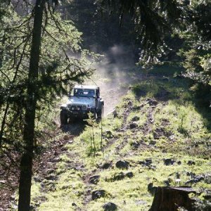
Right at that left is the start of the most serious damage. Someone has knocked over the sign (which was old/obscured) and gone on thru into a sensitive area (some of you may remember this area which was hnown as "The Gunhole"). The "Gunhole" was closed years ago due to the sensitive nature of the area. The damaged area is not directly in the "Gunhole" Area but very near it. The damage is fresh within the last couple of weeks. It is not possible to confuse this newly damaged area as the trail.
I remember this area...didn't they closed it up around 1995...the trail used to hang right, then left up through the trees...in the trees was a very wet spot (the gunhole I assume), then up through the meadow & then hard right on what is the trail today.
The other damaged areas are below this area and it looks like someone possibly got bored with the lack of challenge in this section of trail and decided to make a bypass. This is a double track vehicle that traversed up and did not get thru. This damaged section would present a challenge to anyvehicle except a very capable rig.
The other section that was damaged is purely a bypass established to avoid a snowbank that could not be navigated easily. To most people this snowbank would of turned them back. Which should mean the trail is not passable (ie: closed). But instead somebody decided causing this sort of damage was more important than respecting the trail and respecting the legitimate users rights.
Comes down to "Stay on the Trail or Stay Home".
So of the 4 pics posted, how many of them were up to the right near the Gunhole section? It sounds like most of the damage was in an area that wasn't even part of the legitimate trail system.